
Find Urbana Neighbors by Block
Public records describe places and roles more reliably than they describe a whole household. CCGISC maps the parcels around an Urbana address. Devnet adds the assessment owner, tax mailing line, situs, class, sale, and exemption context. Election tools locate a polling place or test one person's registration, but they do not reveal a block-wide list of voters. City association pages and archive catalogs add civic and historical context.
| Source | What It Shows About a Block | Access |
|---|---|---|
| CCGISC public map | Parcels, lots, boundaries, aerials, districts, nearby addresses | Free viewer; print and identify tools |
| Devnet assessment | Owner, situs, mailing line, PIN, sale and tax facts | Free address or PIN search |
| ElectionLink | Polling location and district context for one address | Free staged form |
| Neighborhood groups | Named civic area and public contact route | City page; no public member roster found |
| CCHA and UFL | Historical clubs, churches, families, photographs, papers | Catalog and collection-specific access |
No row alone answers who lives next door. Keep owner, occupant, voter, permit applicant, deed party, and association contact as distinct roles. The most accurate result states only what the source shows.
Map an Urbana Neighbor Block
Open CCGISC Maps and search the target by address or PIN. Identify the target parcel before selecting the surrounding block face. The public map supports a drawn-box Select By Map tool, Advanced Query, Find Values, Validate, Run Query, sorting, Zoom to Selected, and Identify.
- Note the target PIN, situs address, subdivision or lot, street centerline, and Urbana municipal boundary.
- Turn on parcel and aerial layers. Add zoning, voting precinct, census, or district layers only when they answer a real question.
- Draw a box around parcels touching or facing the block segment. Sort and identify each selected parcel.
- Move each PIN to Devnet or the recorded-deed route, keeping legal lot and street number separate.
- Save the map date and the public role shown for each result. Do not label a tax owner as an occupant.
A full named-street chain is covered by the Urbana street directory. For neighbors, stop at the immediate block or radius so the map remains readable and the task stays focused.
Read Urbana Parcel Layers
Parcel outlines tell more than a row of street numbers. Subdivision and lot layers distinguish legal parcels that may share a drive or building. The municipal line shows whether an address with an Urbana postal label is legally inside Urbana. Precinct and district layers supply civic geography, while historic aerials can show how the block changed.
- Parcel
- A mapped unit of land identified by a permanent index number, or PIN.
- Situs
- The physical parcel address, separate from the tax-bill mailing address.
- Subdivision and lot
- The recorded plat framework used to distinguish nearby pieces of land.
- Identify
- The map tool that opens attributes for a selected feature.
A CCGISC tutorial carries an important local quirk: the ordinary address search may lag behind the Add/Select/Modify Single Address layer. If a new or odd address fails, search its PIN, select it on the map, or call CCGISC at 217-819-3555. The map supports research and printing, not legal boundary analysis.
Locate Urbana Voting Geography
The state voter tool is designed to test one known person's registration. It asks for name, birth date, ZIP, then street number and a ZIP-populated street name. It does not show all names on a block. Illinois law also redacts street number, birth date, phone, Social Security number, identifiable email, and other sensitive fields from public voter-file releases. Address Confidentiality Program participants receive added protection.
The lawful block substitute is geography. Use the CCGISC precinct layer and the Champaign County polling-location search to learn where an address votes. Published election materials can explain the precinct or district. None of those sources says whether a given neighbor cast a ballot or how anyone voted.
The manifest capture of the ElectionLink polling form shows the address-based public route.
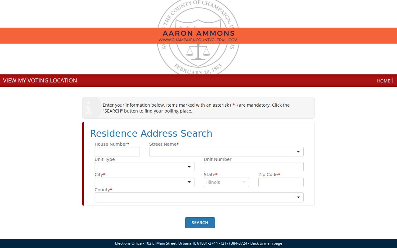
The form connects an Urbana address to election geography without publishing a neighborhood roster.
Contact Urbana Neighborhood Groups
The City of Urbana's new resident information names five neighborhood groups. They are a public route to meetings, area issues, and civic contacts, not a list of residents. No complete public membership directory was found for any group.
| Urbana Group | Area or Role | Public Directory Status |
|---|---|---|
| HEUNA | Historic East Urbana identity and contact | Named by City; member roster not located |
| Middle Urbana | Central Urbana civic identity | Named by City; member roster not located |
| SUNA | Southeast Urbana meetings and contact | Public contact route; no resident list |
| WUNA | West Urbana civic identity | Named by City; member roster not located |
| LNAC | Lincoln Avenue area council | Named by City; member roster not located |
The City neighborhood map also marks Downtown, AmVets II, and other civic areas. Treat those outlines as community context. They may not match parcel, precinct, postal, or subdivision boundaries.
Meet Urbana Neighbors Safely
Urbana's Neighborhood Watch program offers an assigned officer and a meeting structure. Depending on the area, meetings may occur monthly, quarterly, or twice each year. The public contact is PoliceFrontDesk@UrbanaIL.Gov. That route helps residents organize around safety without exposing a private household list.
Church, club, fraternal, and other organization rosters are usually private or collection-specific. The Champaign County Historical Archives and Urbana Free Library may hold older minutes, newsletters, photographs, family papers, railroad records, and church collections. A catalog hit proves that a collection item or finding aid exists, not that every person named in it is indexed online.
Note: Ask a civic group for its public meeting or officer contact, not for personal details about people who have not chosen to publish them.
Compare Urbana Neighbor Tools
Official block sources are slower but easier to verify. A parcel has a PIN and custodian. A polling result has an election authority. A neighborhood contact comes from the City or the group. Commercial neighbor tools may combine marketing files, public records, address histories, and user data without showing which source produced a name.
| Feature | Official Urbana Sources | Commercial Tool Category |
|---|---|---|
| Source trail | Named custodian and dated record | Often blended or unclear |
| Meaning | Defined parcel, district, or civic role | Possible association that needs checking |
| Update and correction | Office explains its cycle and correction route | May lag or require repeated listing control |
| Cost | Core map and lookup routes are free | Details may require payment |
A commercial suggestion is not proof that a person occupies a nearby address. Confirm any useful lead with the parcel, deed, district, archive, or voluntary public contact that actually holds the fact.
Trace Past Urbana Block Life
Current maps show lots, not the people and groups that shaped them. UFL and CCHA collections can add dated photographs, organization papers, church records, local newsletters, oral histories, and address-tagged finding aids. University directories and yearbooks can also place students or staff in a dated campus context.
Search a historic block by street name, direction, house number, organization, and nearby landmark. Preserve the collection title, date, and archive citation. An old caption or directory entry must not be treated as evidence of a present resident. Historical block research is most useful for family history, civic memory, and understanding how a site or association changed.
Protect Urbana Neighbor Privacy
Public parcel records may show a tax owner and mailing address, but not every member of a household. A nearby person can appear as a deed party, permit applicant, voter, business agent, or old directory entry without being a current occupant. DMV personal addresses are restricted. Utility customer and delivery lists were not found as public Urbana sources. Court, vital, juvenile, sealed, medical, and protected voter records have separate limits.
Illinois's Address Confidentiality Program supplies eligible survivors a substitute address for new government records and mail forwarding. Its purpose is safety. Stop when a source is restricted, a person has chosen no public contact, or the only remaining step would intrude on private life.
Lawful use. Research Urbana neighbors for civic, historical, or personal purposes only. Never use a map or record to watch, harass, threaten, or harm anyone.